Maps
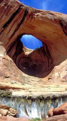
Bow Tie Arch
TOOLS
- The National Map Viewer. USGS
- Web page to convert UTM (Universal Transverse Mercator) coordinates to geodetic positions
- Utah's GIS Portal for topos and much more
- Utah ARC Maps for diverse mapping projects
ACME MAPPER (powered by Google)
- PR Springs (tar sands strip mining proposal)
- Indian Ridge (oil shale strip mining proposal)
- Westwater Farms (Class II injection well for fracking fluids)
- Long Canyon (proposed pump back hydroelectric facility)
- K2O Potash (proposed potash extraction)
- Pinnacle Potash (proposed potash extraction)
BUREAU OF LAND MANAGEMENT (BLM)
- 1999 - Maps of Utah BLM Wilderness Inventory (cache). GPO.
- Oil & Gas parcels adjacent to Moab Area Sole-Source Aquifer
- Exisitng and proposed oil and gas parcels
- BLM and SITLA oil and gas leases
______________________________________
MAPS: BUREAU OF LAND MANAGEMENT (BLM)
Utah BLM: Ownership Maps Circa 1998 to 2007Green River Corridor
White River Corridor
Yampa River CorridorYampa & Cross MountainBUREAU OF LAND MANAGEMENT
UTAH: Ownership and Natural Resource Maps; Circa 1975.
UTAH: Ownership and Natural Resource Maps; Circa 1975.
Canyonlands (SE Utah)
Glen Canyon National Recreation Area (Lake Powell)
- Crossing of the Fathers
- Monitor Butte (San Juan River Arm)
Color Country (SW Utah)
West Desert (Basin and Range)
Highways 50 & 6 and Interstate 70 (Northern Utah)
_____________________________________________
CANYONLANDS NATIONAL PARK
CANYONLANDS WATERSHED COUNCIL
- Moab/Spanish Valley Glen Canyon Aquifer & Synopsis. John C. Dohrenwend.
- Possible extent of energy corridor in Moab. Dohrenwend.
- See also GIS Section
FOUR CORNERS
- Relief Map of the Four Corner States. SAHRA.
GEOLOGY
- Geologic Map of Utah
- Geologic Map of Moab
- Geophysical Provinces of the Colorado Plateau. Hunt.
- Groundwater Classification for Moab/Spanish Valley. UGS.
- Structural geology of La Sal Mountains. Hunt.
- 1997 - Map of recharge areas for the Glen Canyon and valley-fill aquifers, Spanish Valley area, Grand and San Juan Counties, Utah. US Geological Survey. Steiger et al.
- 2001 - Moab sole-source aquifer Color Map & Legend
- 2007 - Septic recommendation map.
- 2007 - Aquifer recharge map (USG) & alternative version (USGS)
- Map: Locations of Moab aquifers and oil & gas parcels
GRAND COUNTY MAPS
Non-Motorized Master Plan
- Index
- Class B Roads.pdf
- Monitor Merrimac
- Klondike Sovereign
- Arches
- Yellow Cat
- Castle Valley
- Cisco Westwater
- Gemini Canyonlands
- Behind the Rocks
- Moab Spanish Valley
- Slickrock Mill Creek
- La Sal Mountains
- Moab 1944. USGS. (High Resolution)
- 01 Moab
- 02 Moab
- Moab 1944. USGS.
- Moab 1944; High Resolution. USGS.
- 01 Moab Spanish Valley
- 02 Moab Spanish Valley
- North Moab Recreation Area
- Trail Mix (table)
- Map: Locations of Moab aquifers and oil & gas parcels
MOAB CITY
- Moab's first plat map (.jpg) (.pdf) 1884 and recorded in 1891.
- Moab in 1916 (.pdf)
- Moab in 1944 (.pdf)
- Moad in recent times (.jpg) (date unknown)
UNIVERSITY OF UTAH
SITLA (State Institutional Trust Lands)
- Digital Plat Maps
- Hatch Point Proposed Land Exchange
- Hatch Point Trade Proposals
- Map of section ownership in Utah
- Map of Green River Industrial Zone
- Map of designated state land sections
- Map state sections in Grand County
- Map state sections in San Juan County
- Map sate section in Emery County
- Map of oil shale resource ownership in Utah
- Utah Recreational Land Exchange Act Grand County
URANIUM MINING MAPS
USGS MAPS
UTAH WATERSHED COORDINATING COUNCIL
UTAH STATE GOVERNMENT
ZONING
OTHER
- Watershed boundaries in the arid lands. Powell Survey.
- Rough sketch of Green/Colorado river divide in Grand County
- Wind Map: USA
- Watershed experiment
1950 to 1993: Kent Frost; professional land and river guide.
- MAPS: Cataract Canyon; USGS 15 Minute Quads; 1952; baseline data before reservoir inundation.
- Upper Cataract: Confluence of Green and Colorado Rivers; Canyonlands National Park (CANY). jpg.
- Middle Cataract Canyon; Mile Long Rapids and Big Drops.; CANY & GCNRA. jpg.
- Lower Cataract Canyon; GCNRA. jpg.
- MAPS: Glen Canyon; USGS 15 Minute Quads; 1952; baseline data before reservoir inundation.
- 01 Hite (includes Narrow Canyon). jpg.
- 02 Mancos Mesa. jpg.
- 03 Mt. Ellsworth. jpg.
- 04 Lake Canyon. jpg.
- 05 Rincon. jpg.
- 06 Navajo Mountain. jpg.
- 07 Cummings Mesa. jpg.
- 08 Gunsight Butte. jpg.
- 09 Leche-E Rock. jpg.
- 10 Lee's Ferry. jpg.
FIELD MAPS of GEORGE SIMMONS
Prints of the topographic maps produced by the USGS dam surveys from 1921 to 1923.
Colorado River
- Sheet A - Lee's Ferry
- Sheet B - Wahweap Canyon
- Sheet D - Kane Creek
- Sheet E - Rock Creek
- Sheet F - Music Temple
- Sheet G - Rincon
- Sheet H - Hansen Creek
- Sheet I - Smith Fork
- Sheet J.- Red Canyon
- Sheet K - White Canyon
- Sheet L - Dark Canyon to North Wash
- Sheet M - Confluence to Dark Canyon
Green River
- Sheet A - Price River
- Sheet B - Three Canyon
- Sheet C - Sand Wash
- Sheet D - Ouray
- Sheet E - Dinosaur NM
Yampa River
Grand Ganyon Plan and Profiles, USGS (not Simmons Collection).