
Oil (Tar) Sands
UPDATE as of September 2023
- All federal leasing for oil shale development in Utah and Colorado have expired or have been relinquished.
- Activities for tar sand development in Utah have ceased.
Oil shale and tar sands remains a speculative industry in the arid lands of the Colorado Plateau. A general lack of water is why the industry will never be viable. Even if alternative chemical washes are used to separate bitumen from sand, for example, it still requires 1.5 to 2 barrels of water to refine a single barrel of synthetic crude. What this extraction will accomplish is physical damage to the Colorado River watershed, which supplies culinary water to nearly 30 million people. It will also create more CO2 in the atmosphere, which is the #1 killer of the Rocky Mountain snowpack, which provides 85% of the Colorado River's total annual water supply. Our watershed needs investors to create a reliable energy supply that will heal the water supply of the Colorado River, not destroy it.
LATEST UPDATES
September, 2017 - US Oil Sands declares receivorship in Canada and bankruptcy in USA
- Canadian receivorship document (insolvency)
- USA document 01 & 02
- ACMO S.a.R.L. receives PR Spring Mine & Press Release from US Oil Sands.
- USO (Utah) LLC receives approval to transfer mining application from US Oil Sands
- News about Petroteq (formally MCW) at Asphalt Ridge (Vernal, UT). Bloomberg News.
Independent Technical Memorandum: Greenhouse Gas & Water Footprints of Oil Shale & Tar Sands Resources & Projects in the Upper Colorado River Basin. 2018, EcoShift. The Executive Summary of this report is HERE.
December, 2016 - Activities report and water quality testing results
November, 2016 - US Oil Sands must apply for a federal contract to appropriate water. Order of the State Engineer; US Oil Sands water right records: 49-2274
November, 2016 - US Oil Sands 3rd Quarter Report: USOS does not have sufficient capital.
###
CLICK HERE to read this color booklet created by Living Rivers and the Colorado Riverkeeper
CLICK HERE to read this investor analysis of US Oil Sands. Seeking Alpha.
CLICK HERE to read information about the Programmatic EIS for oil shale and tar sands in Wyoming, Colorado and Utah
CLICK HERE to watch the first documentary about Utah unconventional fuel called Last Rush for the Wild West: Tar Sands. Oil Shale and the American Frontier.
Read this article about strip mining tar sands in Grand County
To SUBMIT A LETTER of concern to Utah Division of Oil, Gas and Mining click here
____________________________________
INVENTORY OF TAR SAND DEPOSITS IN UTAH
State Land (SITLA)
- 141,020 State Trust acres on which tar sands are known or expected.
- 52,887 State Trust acres under lease for tar sands
- A typical lease lasts 10-years
- Only a very small part of the above acres could be surface mined
- US Oil Sands Lease with SITLA
- US Oil Sands Contract Report. SITLA.
Federal Lands (BLM)
- NOTE: there are no tar sands in Colorado or Wyoming.
- 2008 - Total identified is 430,686 acres
- 2012 - The proposed preferred alternative identifies 91,045 acres
- RECORD OF DECISION (Issued March 22, 2013)
____________________________________
AMERICAN SANDS ENERGY (West Tavaputs Plateau near Mt. Bruin)
- 2014 - Notice of Intent to Commence Large Mining Operations
- 2014 - First Review of NOI by UDOGM
- 2015 - Revised Notice of Intent
____________________________________
ADMINISTRATIVE RECORD OF UTAH DIVISION OF OIL, GAS & MINING (UDOGM)
- UDOGM permit files (complete list)
- Username and password is: ogmguest
- US Oil Sands @ PR Springs for large & small mining permits
- UDOGM Board Notes and Dockets
ADMINISTRATIVE RECORD OF PROPOSED STRIP MINING @ PR SPRINGS
US Oil Sands (Utah) Inc., (formally Earth Energy Resources)
- 2014 - Amended Operation Plan (file reduced); (high rez maps); (text searchable); (appendix text searchable).
- Docket of PR Springs litigation
- UDOGM docket for PR Springs litigation
- DWQ docket for PR Springs litigation
- 2007 - EER Mining Plan PR Springs in Grand and Uintah County
- 2009 - EER Mining Plan PR Springs in Grand and Uintah County
- 2009 - Presentation by Earth Energy Resources
- 2010 - EA for public comment on water well for PR Springs. BLM
- Public Notice: EER proposal for large scale mining of tar sands at PR Springs. Comments are due: 30 days after March 23, 2010.
- Grand County Council Comments
- 2010 - Initial Comments by Non-Profit Groups
- 2011 - Notice of Intent for exploratory drilling of bitumen deposits at PR Springs by Oil Sands USA
- Math - The PR Springs project will provide the nation with 6 hours of oil consumption.
- Analysis Spreadsheet (xls)
- Ophus Process - What we know about the citrus based processing chemical. MSDA reports.
- Patent Application; Lemon Terpenes; Akzo Surfacant 01; Akzo Surfacant 02;
ADMINISTRATIVE RECORD OF UTAH DIVISION OF WATER RIGHTS @ PR SPRINGS (State Engineer)
Water Right for US Oil Sands 49-2274 (a33805)
- Potential Impacts to Perennial Springs from Tar Sand Mining in the Tavaputs Plateau, Utah. Johnson et al.
- Hydrochemical Data from Perrenial Springs in the PR Spring Area of Southern Uinta Basin. Johnson et al.
- Scanned documents for 49-2274
- Map of water rights, leases and properties of US Oil Sand & DeLambert Ranch
- Drill logs for 5 water production wells
- Administrative record @ Utah Division of the State Engineer
- Water right 41-3523 (Uintah County Water Conservancy District)
- Request For Extension Of Time To File Proof Of Beneficial Use
- Hearing of the Protest for Extension to File Proof (audio file)
- Photos of destructive road and well pad activities
Other water rights (adjacent to proposed mine @ 4.5 gallons per minute)
Additional water well information (state and federal)
- Willow Watershed 1406006 (Lower Green/Desolation Canyon).EPA.
- Willow Watershed Water Resources Links. USGS.
- EPA groundwater summary of Uinta Basin
- Map: Water well and pipeline
- Map: Topo of PR Springs
- Proposed water well. Division of Water Rights.
- 2010 - Comments on BLM's EA for water well at PR Springs. Living Rivers.
- Map of well site
- Satellite image of well pad for PR Springs mine
- FOIA - BLM Water Right-of-Way @ PR Springs mine
ADMINISTRATIVE RECORD UTAH DIVISION OF WATER QUALITY (DWQ) for PR SPRINGS
- Consolidated Initial Record as of January 2012
- DWQ website archive
- March 2011 - Appeal to Utah Division of Environmental Quality
- November 2011 - Order on motion to dismiss denied
- May 2012 - Transcript of Hearing Vol. 1 & Vol. 2.
TRANSCRIPTS OF HEARINGS FOR PR SPRINGS STRIP MINING OPERATION
- Informal hearing transcription of 7/27/10
- Compilation of reference materials
- 2011- Prepared testimony from expert witnesses: Elliott Lips & Charles Norris 01 & Charles Norris 02
- 2011 - Transcript of Formal UDOGM Hearing of Feb. 2011.
- 2012 - Transcript of expert witness William Johnson
- May 2012 - Transcript of DWQ Hearing Vol. 1 & Vol. 2.
ADMINISTRATIVE RECORD OF ENVIRONMENTAL PROTECTION ADMINISTRATION (EPA)
Air Quality at Proposed PR Springs Mine
- Part One; Part Two; Part Three; Part Four; Part Five;
- Air Reources and Chemical Processing
- NSPS Subpart Ja
- 2010 - Fact sheet on ozone standards
____________________________________
ASPHALT RIDGE MINING OPERATIONS (near Vernal, Utah)
Crown Asphalt Ridge (CAR) Korea Technology Industry of America (Defunct)
- Website - JAM Industrial, Inc. (Tar sands demonstration project that ended in bankruptcy).
- 2004 - Study Demonstration Process Bitumen Utah Tar Sand. Society of Petroleum Engineers.
- CAR Google Earth
- CAR - Department of Water Quality (DWQ)
- CAR - Public Notice Public Notice
- CAR - Application Letter. 2012.
- CAR - Application. 2012.
- CAR - Application Appendix A Lab Report. 2012.
- CAR - Application Appendix B Well Logs. 2012.
- CAR - Application Attachments. 2012.
- CAR - Statement Of Basis. 2012.
- Comments - Western Resource Advocates and Living Rivers. 2012.
- Response - To WRA and LR. 2012.
MCW Energy Group @ Asphalt Ridge
- MCW Energy - GoogleEarth.
- MCW Energy - Public Notice.
- MCW Energy - DWQ Application.
- MCW Energy - Construction Permit.
- MCW Energy - Statement of Basis.
____________________________________
AIR QUALITY
2013 - Air Quality in the Industrial Heartlnd of Alberta Canada and Potential Impacts to Human Health. Simpson et al.
____________________________________
ARCHEOLOGY
- 2002- Perspectives Revisited: Overview of Cultural Resources Uinta Basin & Tavaputs Plateau. Spangler.
____________________________________
BUREAU OF LAND MANAGEMENT
- 1983 - Uinta Basin Synfuels Development, FInal Environmental Impact Statement. www.riversimulator.org/Pubs/OSTS/Ref/BLMsynfuelsFEIS1983.pdf
- 1983 - Utah Combined Hydrocarbon, Regional Draft Environmental Impact Statement. www.riversimulator.org/Pubs/OSTS/Ref/BLMregionalDEIS1983a.pdf
- 1984 - Utah Combined Hydrocarbon, Regional Final Environmental Impact Statement. www.riversimulator.org/Pubs/OSTS/Ref/BLMregionalFEIS1984.pdf
- 1984 - Book Cliffs Resource Management Plan, Final Environmental Impact Statement. www.riversimulator.org/Pubs/OSTS/Ref/BLMveranalRMP1984.pdf
- 1984 - Air quality assessment for the Environmental Impact Statement on the Federal Oil Shale Management Program.www.riversimulator.org/Pubs/OSTS/Ref/BLMAirQualityOSTS1984.pdf
- 1985 - PR Spring Combined Hydrocarbon Lease Conversion Draft Environmental Impact Statement. www.riversimulator.org/Pubs/OSTS/Ref/BLMprSpringsDEIS1985.pdf
- 1985 - PR Spring Hydrocarbon Lease Conversion Final Environmental Impact Statement. www.riversimulator.org/Pubs/OSTS/Ref/BLMprSpringsFEIS1985.pdf
- 1990 - Winter Ridge Wilderness Study Area. www.riversimulator.org/Pubs/OSTS/Ref/BLMwinterRidgeWSA1990.pdf
- 1999 - Utah Wilderness Inventory. www.riversimulator.org/Pubs/OSTS/Ref/BLMwilderness1999.pdf
- 2013 - Oil Shale & Tar Sands, Programatic Environmental Impact Statement: Official web site.ostseis.anl.gov/documents/index.cfm
- RECORD OF DECISION (Issued March 22, 2013)
Paving Seep Ridge Road in Uintah County
2008 Oil Shale & Tar Sands Programmatic EIS
- Home Page
- Federal Notice
- Environmental Impact Statement
- Record of Decision
- Additional Information
- Tar Sands: Basic Information
- Oil Shale: Basic Information
- Endangered Species List
- Comments of California Attorney General
____________________________________
CORPORATE WEBSITES
- NEW: Company Profiles
- Nevtah Capital Management
- US Oil Sands formerly Earth Energy Resources
- 2007 - EER Mining Plan PR Springs in Grand and Uintah County
- 2009 - EER Mining Plan PR Springs in Grand and Uintah County
- 2013 - US Oil Sands Corporate Presentation
- 2009 - Presentation by Earth Energy Resources
- Korea Technology Industry of America (Defunct)
- Presentation: Mining in Uintah County
- Temple Mountain Energy
- Wentworth Energy (Asphalt Ridge tar sands)
- American Sands Energy Corp
____________________________________
DOCUMENTS
- 2007 - Analysis of Utah Tar Sands. Baxter.
- 2008 - History of Tar Sands in North America. Congressional Research Service.
- 2010 - Energy-Water Nexus: Better Understanding of Water Resources. GAO.
- 2010 - Policy Analysis of Water Availibility and use Issues for Domestic Oil Shale and Oil Sands Development. Univ. or Utah.
- 2010 - American Tar Sands. Willliams.
- 2010 - Water Availability for Tar Sands and Oil Shale. Keiter.
- 2012 - Energy Water Nexus for Utah
- Oil Shale Politics in Utah: Holding Government Officials, Lobbyists, and Corporate Management Accountable to the Public
____________________________________
ECONOMIC VIABILITY
- 2014 - Updated: Energy Initiatives & Imperatives for Utah's 10-Year Strategic Energy Plan 2.0. Governor Herbert.
- 2014 - Drilling Deeper: A Reality Check on US Government Forecasts for a Lasting Tight Oil & Shale Gas Boom. Hughes.
- 2013 - Executive Summary: Tar Sands Oil Shale Market Assessment. U of U.
- 2013 - Oil Shale Market Assessment. U of U.
- 2012 - Investor Oil Shale Risks. CERES.
- 2011 - Economic Impact of Marcellus Shale Gas. Cornell.
- 2011 - Marcellus Shale: What Are The Limitations? Cornell.
- 2010 - Oil Shale: 14 Unanswered Questions. Headwater Economics.
- 2008 - North American Oil Sands History Development Prospects. Congressional Research Service.
- 2008 - Developments In Oil Shale. Congressional Research Service.
- 2007 - Testimonies Oil Shale. RAND.
- 2006 - Oil Shale History Incentives Policy. Congressional Research Service
- 2005 - Oil Shale Development USA. RAND.
____________________________________
ENDANGERED AND THREATENED SPECIES
- Critical Habitat Designation. USFWS.
- Mexican-spotted owl
- Greater sage grouse
- Graham's Penstemon (Photo) (Recent news) (Aid to identify)
- Screen of endangered species at Red Leaf Resources
- Map 01 & Map 02: endangered species @ Red Leaf Resources
- Sage grouse brood habitat at PR Springs
- Critical Habitat Map. The Wilderness Society.
____________________________________
GEOLOGY
Oil Shale and Tar Sands web page. Utah Geologic Survey.
Tar Sands Bibliography (2009). UGS.
USGS publications library
- 2013 - Hydrochemical Data from Perrennial Springs in the PR Spring Area. Johnson.
- 2008 - Oil shale and tar sands Programmatic EIS. BLM.
- 2008 - Holocene Debris Flows on the Colorado Plateau. Webb.
- 1996 - Tar Sands Resources Uinta Basin. Blackett.
- 1992 - Hydrocarbons along proposed Book Cliffs Highway. UGS.
- 1984 - Characteristics of PR Springs Tar Sands. Dana.
- 1984 - Economic Potential of PR Springs Tar Sands. UGS.
- 1980 - PR Springs Tar Sands. UGS; Dahm.
- 1980 - Characteristics of PR Springs Tar Sand Deposits. DOE.
- 1980 - Characterization of Utah Bitumen. BoM.
- 1980 - Properties of Utah Tar Sands. BoM.
- 1979 - Geology Oil Impregnated Sandstone Utah. UGS; Campbell.
- 1975 - Mineral Resources of Uintah Ouray Reservation. USGS.
- 1971 - Grand County Tar Sands. UGS; Gwynn.
- 1970 - PR Springs Tar Sands. UGS; Byrd.
- 1966 - PR Springs Tar Sands. Open File Report; UGS.
- 1966 - PR Springs stratigraphic column of tar sand deposits
- 1964 - Bituminous Sandstone Uinta Basin. Covington.
Geologic Bibliography
GROUND WATER
- 2015 - Potential Impacts to Perennial Springs from Tar Sand Mining in the Tavaputs Plateau, Utah. Johnson et al.
- 2013 - Hydrochemical Data from Perrennial Springs in the PR Spring Area. Johnson.
- 1983 - Potential Impacts on Hydrology from Tar Sands Industry. USGS.
- 1975 - Hydrologic Reconnaisance of Southern Uinta Basin, Utah and Colorado. Price & Miller.
____________________________________
- 2009 - Letter from Western Resource Advocates.
- Petitioners withdraw with prejudice
- PR Springs Settlement. SUWA, Sierra Club, Western Resource Advocates.
- Comments on Air Quality from Oil and Gas Development in Dixie Nat. Forest
- 2010 - Montana Environmental Information Center v BLM
- 2010 - Mexican spotted owl critical habitat decision
- 2010 - History of Mexican spotted owl appeal
____________________________________
MAPS & GIS
- BLM PEIS: Tri-state deposits
- Uinta Basin
Google Earth
- Tar sand deposits 01. Data from BLM PEIS.
- Tar sand deposits 02. Data from BLM PEIS.
- Satellite image of well pad for PR Springs mine
PR Springs
- Map of 1966
- Tar sand saturation map of 1966
- 1966 - PR Springs stratigraphic column of tar sand deposits
- Stratigraphic column Section 27 (Monument Ridge Road Junction)
- Location of spings
- Map: Topo of PR Springs
- Map: Proposed mining operations @ PR Springs
- Location of tar sand deposits in Uinta Basin
Green River Refinery (proposed) (click here)
SITLA
- Oil shale resource ownership
- Parcels in Grand County (14.9%; about 550 sq. miles)
- US Oil Sands Lease with SITLA
- US Oil Sands Contract Report. SITLA.
University of Utah
Other
- Critical Habitat Map. The Wilderness Society.
- Map - Where tar sand oil is refined
- Map: PR Springs water well and pipeline
- Map: Topo of PR Springs
- Map: Proposed mining operations @ PR Springs
____________________________________
NEWS
- 6/15/10 - Wildflower vs. Oil Shale. Salt Lake Weekly.
- 11/30/10 - GAO: More research needed on oil shale, water
- 9/17/2007 - Tar sands, oil shale. Energy Bulletin.
- 3/17/2010 - First US Tar Sands to Break Ground in Utah.
- 3/18/10 - Tar sand industry comes to eastern Utah.
- 3/24/10 - Decision on wildflower protection expected soon. Assoc. Press.
- 3/28/10 - Company seeks first U.S. oil sands project in Utah. SL Tribune.
- 3/29/10 - Sage Grouse will play role in Western energy development.Marten Law.
- 4/29/10 - Salazar aide - Oil shale not ready for prime time
____________________________________
NON-PROFIT ORGANIZATIONS
- Document archive. Western Resource Advocates.
- Fossil Foolishness. Western Resource Advocates
- Northern Rockies Rising Tide
- CERES Report on Oil Shale/Water Nexus.
- Tar Sands: Feeling the climate crisis. FOE Europe.
- Dirty Oil. Greenpeace.
- 2011 - Between a Rock and a Dry Place: The Impact of Oil Shale Development and Climate Change on the Colorado River Basin Water Supply. NRDC
____________________________________
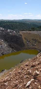
PHOTOS
- Baseline Map: Drill Test Sites PR Springs
- Book Cliffs Divide Road Grand County; Reduced
- Camp One; Reduced
- Camp Two; Reduced
- Drill Pads; Reduced
- East Canyon Grand County Approach; Reduced
- Equipment Yard; Reduced
- Landscapes; Reduced
- Neighboring Gas Well; Reduced
- Pit; Reduced
- Processing Site; Reduced
- Products; Reduced
- PRsprings; Reduced
- Water Well Site One; Reduced
- Earth Energy Resources @ PR Springs, June 2010
- Earth Energy Resources test pit: #1; #2; #3; #4;
- BLM PEIS photos
Aerial Photos
- Aerial photos of East Tavaputs Plateau. Large file. Includes operations by US Oil Sands and Red Leaf Resources; areas of chained trees; wilderness and roadless areas.
- Tar sand mining boundary of PR Spring 01 (blue line is Grand & Uintah border)
- Tar sand mining boundary of PR Spring 02
Satellite Images
____________________________________
TRADE ASSOCIATIONS
- White Paper. Utah Mining Association.
____________________________________
UNIVERSITY
- 2007 - Utah Tar Sands: Worth the Energy?
- 2009 - Oil Shale Report. University of Colorado at Boulder.
- University of Utah ICSE Digital Repository
- 2009 - Western US Tar Sands Conference
____________________________________
USGS
- Oil shale and tar sands interactive web page (excellent resource)
- 1995 - Surface disturbances and the role of accelerating erosion. Belnap.
- Graphic: tar sand deposits in the USA.
____________________________________
UTAH GOVERNMENT
- Home page: Utah Oil, Gas & Mining
- Public records: Utah Oil, Gas & Mining. (Username and password is ogmguest)
- FTP Site. Utah Oil Gas & Mining
- PR Springs water right 01 and 02. Utah Division of Water Rights.
- 1980 - An Assessment of Oil Shale and Tar Sands Development
- 2009 - Bibliography of tar sand deposits & map. Utah Geological Survey.
- 2009 - Approval of PR Springs strip mine for tar sand. UDOGM.
2010 - Notice regarding PR Springs Mine to Grand County Council. UDOGM. - 2012 - Energy Water Nexus for Utah
____________________________________
VIDEO
- Fossil Foolishness. Western Resource Advocates.
- A film by Leslie Iwerks
- The Tar Sands Blow
- Tar Sands, Canadian Broadcasting Corporation
- Red Leaf Resources. EcoFLight.
____________________________________
WILDLIFE
Southest Utah (includes East Tavaputs Plateau)